Title:
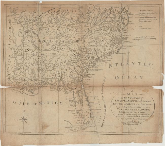
“A Map of the States of Virginia, North Carolina, South Carolina and Georgia; Comprehending the Spanish Provinces of East and West Florida: Exhibiting the Boundaries as Fixed by the Late Treaty of Peace...”
Map Maker:
Joseph Purcell
This is the scarce Vint & Anderson edition of this... (full text available to subscribers)
| Item Detail |
| |
| |
MapMaker: |
Joseph Purcell
|
|
| |
| |
Subject: |
Southern United States, Franklin |
|
| |
Period/Size: |
1800 / 11.6" x 14.0" (29.5 x 35.6 cm)
|
|
| |
Color: |
Black & White
|
|
| |
Condition: |
(C+) Issued folding with toning that is more prominent near the top border along with scattered staining and foxing. There are a number of fold separations that have been closed on verso with archival tape with some small loss along the fold at both left (condition help) |
|
| |
Source: |
A Concise System of Modern Geography |
|
| |
References: |
Dotson & Baker (OWA) #11.2; Baynton-Williams (TMC-72) p. 16, #6; McCorkle (18th C. Geography Books) #438-6 (Vol 2). |
|
| |
|
|
| Sales Information |
| |
| |
Price: |
|
|
| |
| |
Offered by: |
Old World Auctions |
|
| |
Catalog: |
Auction No. 167 - Antique Maps, Charts, Atlases & Globes (9435) |
|
| |
Lot/Item #: |
117 |
|
| |
| |
Date: |
03/2018
|
|
| |
| |
|
Antique Maps - Valuation and Pricing, Descriptions, Resources |
|
Home |
Information |
Search |
Register |
Contact Us |
Site Map
Americana Exchange, Inc. © 1999 - 2024 Americana Exchange, Inc.. All rights reserved.
OldMaps.com, the OldMaps.com logo and
AMPR are service marks or registered service marks of Americana Exchange, Inc..
|