Title:
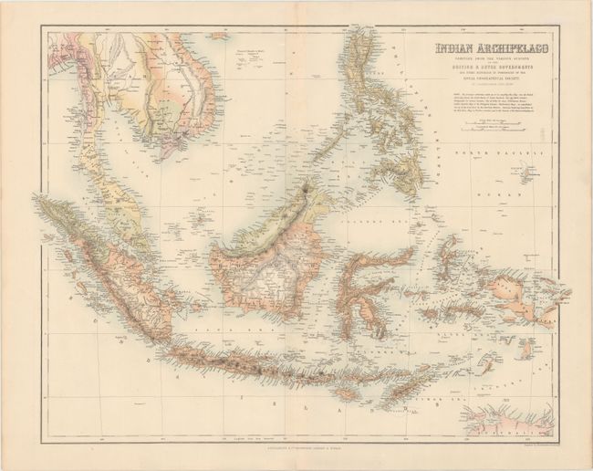
“Indian Archipelago Compiled from the Various Surveys of the British & Dutch Governments and Other Materials in Possession of the Royal Geographical Society”
Map Maker:
John Bartholomew, Sr.
This fine, large map includes the Gulf of Siam, Ca... (full text available to subscribers)
| Item Detail |
| |
| |
MapMaker: |
John Bartholomew, Sr.
|
|
| |
| |
Subject: |
Southeast Asia |
|
| |
Period/Size: |
1860 / 16.2" x 21.0" (41.2 x 53.4 cm)
|
|
| |
Color: |
Colored
|
|
| |
Condition: |
(A) A bright sheet with full original color, a few tiny spots of foxing along the centerfold at top, minor toning along the edges of the sheet, and a short centerfold separation confined to the bottom blank margin. (condition help) |
|
| |
Source: |
Royal Illustrated Atlas |
|
| |
References: |
|
|
| |
|
|
| Sales Information |
| |
| |
Price: |
|
|
| |
| |
Offered by: |
Old World Auctions |
|
| |
Catalog: |
Auction No. 167 - Antique Maps, Charts, Atlases & Globes (9435) |
|
| |
Lot/Item #: |
384 |
|
| |
| |
Date: |
03/2018
|
|
| |
| |
|
Antique Maps - Valuation and Pricing, Descriptions, Resources |
|
Home |
Information |
Search |
Register |
Contact Us |
Site Map
Americana Exchange, Inc. © 1999 - 2024 Americana Exchange, Inc.. All rights reserved.
OldMaps.com, the OldMaps.com logo and
AMPR are service marks or registered service marks of Americana Exchange, Inc..
|