Title:
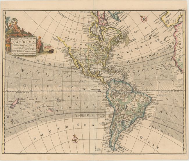
“A New and Accurate Map of America. Drawn from the Most Approved Modern Maps and Charts, and Adjusted by Astronomical Observations: Exhibiting the Course of the Trade Winds Both in Atlantic & Pacific Oceans”
Map Maker:
Emanuel Bowen
This attractive map of the Americas illustrates th... (full text available to subscribers)
| Item Detail |
| |
| |
MapMaker: |
Emanuel Bowen
|
|
| |
| |
Subject: |
Western Hemisphere - America |
|
| |
Period/Size: |
1744 / 13.8" x 17.6" (35.1 x 44.7 cm)
|
|
| |
Color: |
Colored
|
|
| |
Condition: |
(B+) A crisp impression on paper with fleur-de-lis and "IV" watermarks and a centerfold separation at bottom that has been archivally repaired. The side margins are a bit narrow but still ample for framing. (condition help) |
|
| |
Source: |
John Harris' Navigantium atque Itinerantium Bibliotheca |
|
| |
References: |
Shirley (BL Atlases) G.HARR-1a #15. |
|
| |
|
|
| Sales Information |
| |
| |
Price: |
|
|
| |
| |
Offered by: |
Old World Auctions |
|
| |
Catalog: |
Auction No. 168 - Antique Maps, Charts, Atlases & Globes (9436) |
|
| |
Lot/Item #: |
75 |
|
| |
| |
Date: |
06/2018
|
|
| |
| |
|
Antique Maps - Valuation and Pricing, Descriptions, Resources |
|
Home |
Information |
Search |
Register |
Contact Us |
Site Map
Americana Exchange, Inc. © 1999 - 2024 Americana Exchange, Inc.. All rights reserved.
OldMaps.com, the OldMaps.com logo and
AMPR are service marks or registered service marks of Americana Exchange, Inc..
|