Title:
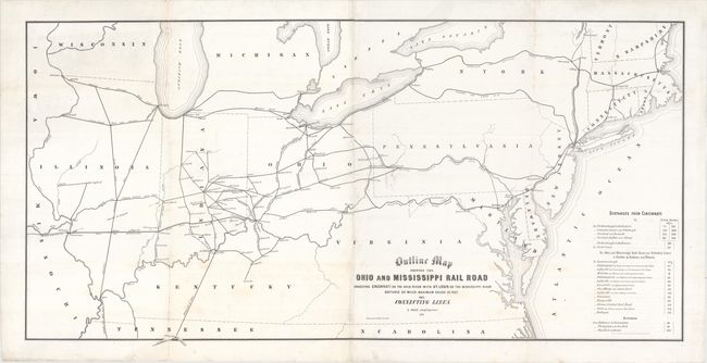
“Outline Map Shewing the Ohio and Mississippi Rail Road Connecting Cincinnati on the Ohio River with St. Louis on the Mississippi River...”
Map Maker:
Railroad Companies
This very rare map shows the growing railroad netw... (full text available to subscribers)
| Item Detail |
| |
| |
MapMaker: |
Railroad Companies
|
|
| |
| |
Subject: |
Eastern United States, Railroads |
|
| |
Period/Size: |
1851 / 19.3" x 38.9" (49.1 x 98.8 cm)
|
|
| |
Color: |
Black & White
|
|
| |
Condition: |
(B+) A dark impression on a bright sheet with faint scattered foxing at bottom and numerous fold separations that have been archivally repaired on verso. (condition help) |
|
| |
Source: |
|
|
| |
References: |
|
|
| |
|
|
| Sales Information |
| |
| |
Price: |
|
|
| |
| |
Offered by: |
Old World Auctions |
|
| |
Catalog: |
Auction No. 168 - Antique Maps, Charts, Atlases & Globes (9436) |
|
| |
Lot/Item #: |
156 |
|
| |
| |
Date: |
06/2018
|
|
| |
| |
|
Antique Maps - Valuation and Pricing, Descriptions, Resources |
|
Home |
Information |
Search |
Register |
Contact Us |
Site Map
Americana Exchange, Inc. © 1999 - 2024 Americana Exchange, Inc.. All rights reserved.
OldMaps.com, the OldMaps.com logo and
AMPR are service marks or registered service marks of Americana Exchange, Inc..
|