Title:
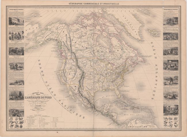
“Nouvelle Carte Illustree de l'Amerique du Nord Indiquant les Grandes Divisions Physiques, la Distribution Geographique des Vegetaux et des Mineraux...”
Map Maker:
Alexander A. Vuillemin
This superb large chart from this scarce nineteent... (full text available to subscribers)
| Item Detail |
| |
| |
MapMaker: |
Alexander A. Vuillemin
|
|
| |
| |
Subject: |
North America |
|
| |
Period/Size: |
1855 / 23.6" x 33.1" (60.0 x 84.1 cm)
|
|
| |
Color: |
Colored
|
|
| |
Condition: |
(B+) Original outline color with a centerfold separation at bottom that extends 2.5" into the image which has been closed on verso with archival tape. There is light scattered foxing, remnants of a label at top right, and some short edge tears confined t (condition help) |
|
| |
Source: |
|
|
| |
References: |
|
|
| |
|
|
| Sales Information |
| |
| |
Price: |
|
|
| |
| |
Offered by: |
Old World Auctions |
|
| |
Catalog: |
Auction No. 168 - Antique Maps, Charts, Atlases & Globes (9436) |
|
| |
Lot/Item #: |
108 |
|
| |
| |
Date: |
06/2018
|
|
| |
| |
|
Antique Maps - Valuation and Pricing, Descriptions, Resources |
|
Home |
Information |
Search |
Register |
Contact Us |
Site Map
Americana Exchange, Inc. © 1999 - 2024 Americana Exchange, Inc.. All rights reserved.
OldMaps.com, the OldMaps.com logo and
AMPR are service marks or registered service marks of Americana Exchange, Inc..
|