Title:
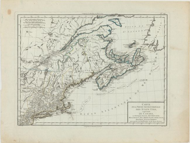
“Carte de la Partie Septentrionale des Etats Unis, Comprenant le Canada, la Nouvelle Ecosse, New Hampshire, Massachuset's Bay, Rhode-Island, Connecticut, New-Yorck, Etat de Vermont...”
Map Maker:
Pierre Francois Tardieu
This striking map of the Northeast extends from Ph... (full text available to subscribers)
| Item Detail |
| |
| |
MapMaker: |
Pierre Francois Tardieu
|
|
| |
| |
Subject: |
Eastern United States & Canada |
|
| |
Period/Size: |
1797 / 12.6" x 16.8" (32.0 x 42.7 cm)
|
|
| |
Color: |
Colored
|
|
| |
Condition: |
(A) A sharp impression on bluish paper with a small rust spot by Nova Scotia, and a tiny worm hole that is only visible when held up to light. A couple edge tears in the bottom left blank margin have been closed with old paper on verso. (condition help) |
|
| |
Source: |
Atlas Universel de Geographie Physique et Politique |
|
| |
References: |
McCorkle #797.5. |
|
| |
|
|
| Sales Information |
| |
| |
Price: |
|
|
| |
| |
Offered by: |
Old World Auctions |
|
| |
Catalog: |
Auction No. 168 - Antique Maps, Charts, Atlases & Globes (9436) |
|
| |
Lot/Item #: |
137 |
|
| |
| |
Date: |
06/2018
|
|
| |
| |
|
Antique Maps - Valuation and Pricing, Descriptions, Resources |
|
Home |
Information |
Search |
Register |
Contact Us |
Site Map
Americana Exchange, Inc. © 1999 - 2024 Americana Exchange, Inc.. All rights reserved.
OldMaps.com, the OldMaps.com logo and
AMPR are service marks or registered service marks of Americana Exchange, Inc..
|