Title:
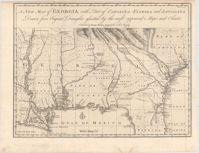
“A New Map of Georgia, with Part of Carolina, Florida and Louisiana. Drawn from Original Draughts, Assisted by the Most Approved Maps and Charts”
Map Maker:
Emanuel Bowen
Scarce and important early map of colonial Georgia... (full text available to subscribers)
| Item Detail |
| |
| |
MapMaker: |
Emanuel Bowen
|
|
| |
| |
Subject: |
Colonial Southeastern United States |
|
| |
Period/Size: |
1748 / 14.3" x 18.8" (36.4 x 47.8 cm)
|
|
| |
Color: |
Black & White
|
|
| |
Condition: |
(A) A crisp impression with a few extraneous creases along the fold at left that have been pressed flat and several tiny edge tears confined to the blank margins closed on verso with archival materials. Minor marginal soiling. (condition help) |
|
| |
Source: |
Harris' A Complete Collection of Voyages and Travels |
|
| |
References: |
Cumming (SE) #267; TMC, Issue 19, p.27-31. |
|
| |
|
|
| Sales Information |
| |
| |
Price: |
|
|
| |
| |
Offered by: |
Old World Auctions |
|
| |
Catalog: |
Auction No. 168 - Antique Maps, Charts, Atlases & Globes (9436) |
|
| |
Lot/Item #: |
178 |
|
| |
| |
Date: |
06/2018
|
|
| |
| |
|
Antique Maps - Valuation and Pricing, Descriptions, Resources |
|
Home |
Information |
Search |
Register |
Contact Us |
Site Map
Americana Exchange, Inc. © 1999 - 2024 Americana Exchange, Inc.. All rights reserved.
OldMaps.com, the OldMaps.com logo and
AMPR are service marks or registered service marks of Americana Exchange, Inc..
|