Title:
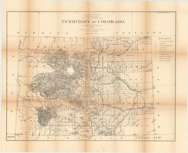
“Territory of Colorado”
Map Maker:
General Land Office
This is a scarce edition of this large survey map ... (full text available to subscribers)
| Item Detail |
| |
| |
MapMaker: |
General Land Office
|
|
| |
| |
Subject: |
Colorado |
|
| |
Period/Size: |
1876 / 22.8" x 29.6" (58.0 x 75.2 cm)
|
|
| |
Color: |
Black & White
|
|
| |
Condition: |
(B) Issued folding with toning along the fold lines and numerous short splits at fold intersections. Several additional fold separations along the lower fold at left have been closed on verso with archival tape. (condition help) |
|
| |
Source: |
|
|
| |
References: |
Phillips (Maps) p. 242. |
|
| |
|
|
| Sales Information |
| |
| |
Price: |
|
|
| |
| |
Offered by: |
Old World Auctions |
|
| |
Catalog: |
Auction No. 168 - Antique Maps, Charts, Atlases & Globes (9436) |
|
| |
Lot/Item #: |
230 |
|
| |
| |
Date: |
06/2018
|
|
| |
| |
|
Antique Maps - Valuation and Pricing, Descriptions, Resources |
|
Home |
Information |
Search |
Register |
Contact Us |
Site Map
Americana Exchange, Inc. © 1999 - 2024 Americana Exchange, Inc.. All rights reserved.
OldMaps.com, the OldMaps.com logo and
AMPR are service marks or registered service marks of Americana Exchange, Inc..
|