Title:
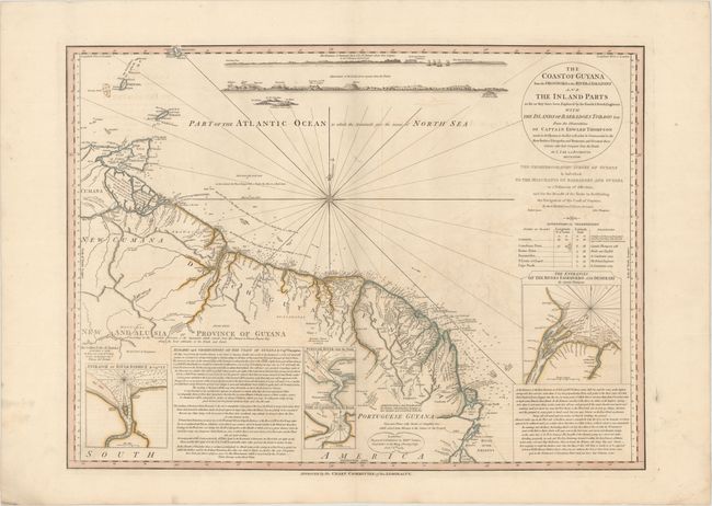
“The Coast of Guyana from the Oroonoko to the River of Amazons and the Inland Parts as Far as They Have Been Explored by the French & Dutch Engineers with the Islands of Barbadoes Tobago &ca...”
Map Maker:
Louis Stanislas d'Arcy Delarochette
This detailed map gives good information both on l... (full text available to subscribers)
| Item Detail |
| |
| |
MapMaker: |
Louis Stanislas d'Arcy Delarochette
|
|
| |
| |
Subject: |
Guyana, Suriname, French Guiana |
|
| |
Period/Size: |
1783 / 19.8" x 26.9" (50.3 x 68.4 cm)
|
|
| |
Color: |
Colored
|
|
| |
Condition: |
(B+) Contemporary color on sturdy paper with light offsetting and a 1" tear above the compass rose that has been closed on verso with archival material. (condition help) |
|
| |
Source: |
General Atlas |
|
| |
References: |
|
|
| |
|
|
| Sales Information |
| |
| |
Price: |
|
|
| |
| |
Offered by: |
Old World Auctions |
|
| |
Catalog: |
Auction No. 168 - Antique Maps, Charts, Atlases & Globes (9436) |
|
| |
Lot/Item #: |
392 |
|
| |
| |
Date: |
06/2018
|
|
| |
| |
|
Antique Maps - Valuation and Pricing, Descriptions, Resources |
|
Home |
Information |
Search |
Register |
Contact Us |
Site Map
Americana Exchange, Inc. © 1999 - 2024 Americana Exchange, Inc.. All rights reserved.
OldMaps.com, the OldMaps.com logo and
AMPR are service marks or registered service marks of Americana Exchange, Inc..
|