Title:
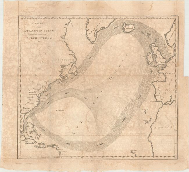
“A Chart of the Atlantic Ocean, Exhibiting the Course of the Gulph Stream, &c.”
Map Maker:
Benjamin Franklin
Benjamin Franklin first published his groundbreaki... (full text available to subscribers)
| Item Detail |
| |
| |
MapMaker: |
Benjamin Franklin
|
|
| |
| |
Subject: |
North Atlantic, Gulf Stream |
|
| |
Period/Size: |
1808 / 12.3" x 13.6" (31.3 x 34.6 cm)
|
|
| |
Color: |
Black & White
|
|
| |
Condition: |
(B) Issued folding with toning and mottling, but the paper is still structurally sound. An edge tear confined to the right blank margin has been closed on verso with archival tape. (condition help) |
|
| |
Source: |
Memoirs of the Life and Writings of Benjamin Franklin |
|
| |
References: |
|
|
| |
|
|
| Sales Information |
| |
| |
Price: |
|
|
| |
| |
Offered by: |
Old World Auctions |
|
| |
Catalog: |
Auction No. 168 - Antique Maps, Charts, Atlases & Globes (9436) |
|
| |
Lot/Item #: |
412 |
|
| |
| |
Date: |
06/2018
|
|
| |
| |
|
Antique Maps - Valuation and Pricing, Descriptions, Resources |
|
Home |
Information |
Search |
Register |
Contact Us |
Site Map
Americana Exchange, Inc. © 1999 - 2024 Americana Exchange, Inc.. All rights reserved.
OldMaps.com, the OldMaps.com logo and
AMPR are service marks or registered service marks of Americana Exchange, Inc..
|