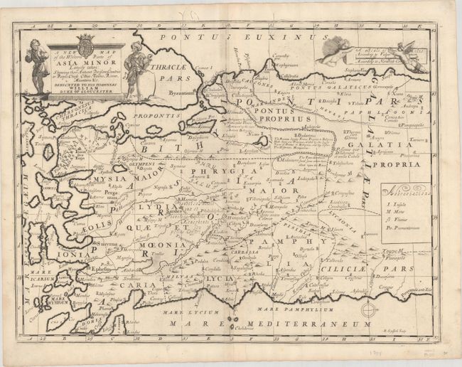
Title:
“A New Map of the Western Parts of Asia Minor Largely Taken: Shewing Their Antient Divisions, Countries or People, Chiefe Cities, Towns, Rivers, Mountains &c.”
Map Maker:
Edward Wells
This handsome map covers the western portion of pr... (full text available to subscribers)
| Item Detail |
| |
| |
MapMaker: |
Edward Wells
|
|
| |
| |
Subject: |
Turkey |
|
| |
Period/Size: |
1701 / 14.4" x 19.3" (36.6 x 49.1 cm)
|
|
| |
Color: |
Black & White
|
|
| |
Condition: |
(B+) A dark impression on a clean sheet of watermarked paper with faint offsetting adjacent to the centerfold and a pair of worm tracks along the top border. (condition help) |
|
| |
Source: |
A New Sett of Maps both of Antient and Present Geography |
|
| |
References: |
Shirley (BL Atlases) T.WELL-1a #31. |
|
| |
|
|
| Sales Information |
| |
| |
Price: |
|
|
| |
| |
Offered by: |
Old World Auctions |
|
| |
Catalog: |
Auction No. 168 - Antique Maps, Charts, Atlases & Globes (9436) |
|
| |
Lot/Item #: |
596 |
|
| |
| |
Date: |
06/2018
|
|
| |
| |
|
Antique Maps - Valuation and Pricing, Descriptions, Resources |
|
Home |
Information |
Search |
Register |
Contact Us |
Site Map
Americana Exchange, Inc. © 1999 - 2024 Americana Exchange, Inc.. All rights reserved.
OldMaps.com, the OldMaps.com logo and
AMPR are service marks or registered service marks of Americana Exchange, Inc..
|