Title:
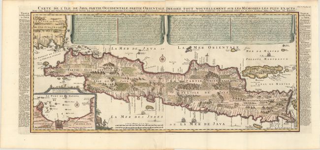
“Carte de l'Ile de Java: Partie Occidentale, Partie Orientale, Dressee Tout Nouvellement sur les Memoires les Plus Exacts...”
Map Maker:
Henry Abraham Chatelain
This important large-scale chart of Java is one of... (full text available to subscribers)
| Item Detail |
| |
| |
MapMaker: |
Henry Abraham Chatelain
|
|
| |
| |
Subject: |
Java, Indonesia |
|
| |
Period/Size: |
1720 / 14.9" x 34.0" (37.9 x 86.4 cm)
|
|
| |
Color: |
Colored
|
|
| |
Condition: |
(A) A sharp impression on clean, bright sheets with the Strasburg Lily and "IV" watermarks. There is minor toning along the edges of the sheets and a small rust spot at bottom left. (condition help) |
|
| |
Source: |
Atlas Historique |
|
| |
References: |
|
|
| |
|
|
| Sales Information |
| |
| |
Price: |
|
|
| |
| |
Offered by: |
Old World Auctions |
|
| |
Catalog: |
Auction No. 168 - Antique Maps, Charts, Atlases & Globes (9436) |
|
| |
Lot/Item #: |
643 |
|
| |
| |
Date: |
06/2018
|
|
| |
| |
|
Antique Maps - Valuation and Pricing, Descriptions, Resources |
|
Home |
Information |
Search |
Register |
Contact Us |
Site Map
Americana Exchange, Inc. © 1999 - 2024 Americana Exchange, Inc.. All rights reserved.
OldMaps.com, the OldMaps.com logo and
AMPR are service marks or registered service marks of Americana Exchange, Inc..
|