Rister or Sign In to see pricing information


Title:

A Plan of the City & Harbour of Louisburg; Shewing That Part of Gabarus Bay in Which the English Landed, Also Their Encampment During the Siege in 1745

Map Maker:

Anonymous

A Plan of the City & Harbour of Louisburg; Shewing That Part of Gabarus Bay in Which the English Landed, Also Their Encampment During the Siege in 1745

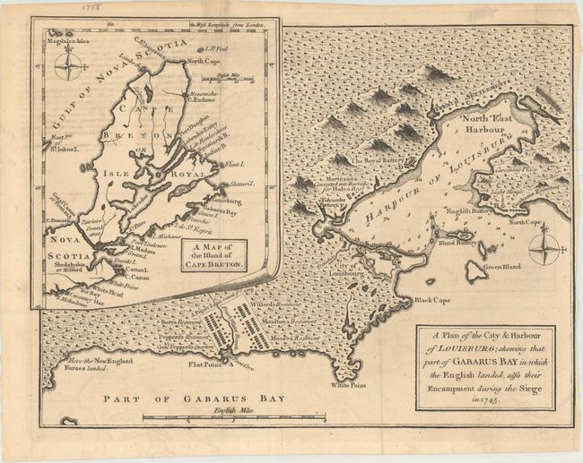
This historical pre-French and Indian War m... (full text available to subscribers)
Item Detail
 
  MapMaker:  

Anonymous


  Subject:  Nova Scotia, Canada  
  Period/Size:  1758 / 7.6" x 10.1"  (19.3 x 25.7 cm)  
  Color:  Black & White  
  Condition:  (B+) A crisp impression issued folding with some light offsetting. The right margin has been trimmed close to the neatline. (condition help)  
  Source:  Gentleman's Magazine  
  References:  Jolly #GENT-114.  
 
 
Sales Information
 
  Price: 

Please register your email to view records, or sign in with email address to see records


  Offered by:  Old World Auctions  
  Catalog:  Auction No. 169 - Antique Maps, Charts, Atlases & Globes (9467)  
  Lot/Item #:  125  
 
  Date:  09/2018  


Antique Maps - Valuation and Pricing, Descriptions, Resources


Home | Information | Search | Register | Contact Us | Site Map

Americana Exchange, Inc. © 1999 - 2024 Americana Exchange, Inc.. All rights reserved. OldMaps.com, the OldMaps.com logo and
AMPR are service marks or registered service marks of Americana Exchange, Inc..