Title:
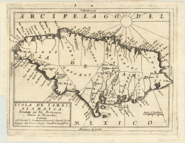
“Isola de Iames, o Giamaica, Possedutta del Re Britannico, Divisa in Parrocchie...”
Map Maker:
Vicenzo Maria Coronelli
This map of Jamaica is divided into parishes and n... (full text available to subscribers)
| Item Detail |
| |
| |
MapMaker: |
Vicenzo Maria Coronelli
|
|
| |
| |
Subject: |
Jamaica |
|
| |
Period/Size: |
1692 / 8.7" x 11.4" (22.1 x 29.0 cm)
|
|
| |
Color: |
Black & White
|
|
| |
Condition: |
(A) A dark impression that is slightly uneven at far left. Issued folding, now flattened, with a binding trim at left. (condition help) |
|
| |
Source: |
|
|
| |
References: |
Kapp (MCC-42) #36. |
|
| |
|
|
| Sales Information |
| |
| |
Price: |
|
|
| |
| |
Offered by: |
Old World Auctions |
|
| |
Catalog: |
Auction No. 169 - Antique Maps, Charts, Atlases & Globes (9467) |
|
| |
Lot/Item #: |
355 |
|
| |
| |
Date: |
09/2018
|
|
| |
| |
|
Antique Maps - Valuation and Pricing, Descriptions, Resources |
|
Home |
Information |
Search |
Register |
Contact Us |
Site Map
Americana Exchange, Inc. © 1999 - 2024 Americana Exchange, Inc.. All rights reserved.
OldMaps.com, the OldMaps.com logo and
AMPR are service marks or registered service marks of Americana Exchange, Inc..
|