Title:
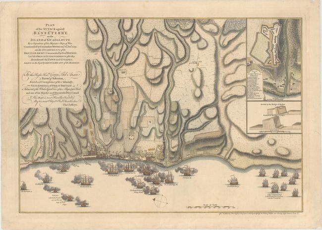
“Plan of the Attack Against Basseterre on the Island of Guadaloupe by a Squadron of This Majesty's Ships of Wars Commanded by Commodore Moore on ye 22d. Jan.y 1759 ...”
Map Maker:
Thomas Jefferys
This superb map depicts the British military actio... (full text available to subscribers)
| Item Detail |
| |
| |
MapMaker: |
Thomas Jefferys
|
|
| |
| |
Subject: |
Basse-Terre, Guadeloupe |
|
| |
Period/Size: |
1760 / 12.8" x 18.6" (32.6 x 47.3 cm)
|
|
| |
Color: |
Colored
|
|
| |
Condition: |
(A) Crisp impression on paper with a Strasburg bend and lily watermark. There are archival repairs to several chips and tears all confined to the blank margins. (condition help) |
|
| |
Source: |
General Topography of North America and the West Indies |
|
| |
References: |
Shirley (BL Atlases) T.JEF-1a. |
|
| |
|
|
| Sales Information |
| |
| |
Price: |
|
|
| |
| |
Offered by: |
Old World Auctions |
|
| |
Catalog: |
Auction No. 169 - Antique Maps, Charts, Atlases & Globes (9467) |
|
| |
Lot/Item #: |
371 |
|
| |
| |
Date: |
09/2018
|
|
| |
| |
|
Antique Maps - Valuation and Pricing, Descriptions, Resources |
|
Home |
Information |
Search |
Register |
Contact Us |
Site Map
Americana Exchange, Inc. © 1999 - 2024 Americana Exchange, Inc.. All rights reserved.
OldMaps.com, the OldMaps.com logo and
AMPR are service marks or registered service marks of Americana Exchange, Inc..
|