Title:
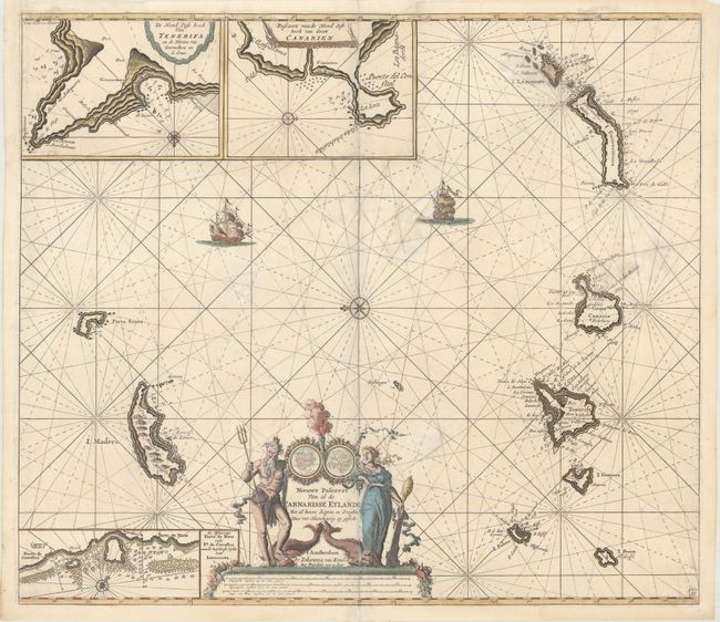
“Nieuwe Pascaert van al de Carnarisse Eylande met al Hunne Diepten en Drooghte dus ver Naeukeurig op Gestelt”
Map Maker:
Johannes van Keulen
This handsome sea chart covers the Canary Islands ... (full text available to subscribers)
| Item Detail |
| |
| |
MapMaker: |
Johannes van Keulen
|
|
| |
| |
Subject: |
Canary Islands |
|
| |
Period/Size: |
1687 / 19.4" x 22.3" (49.3 x 56.7 cm)
|
|
| |
Color: |
Colored
|
|
| |
Condition: |
(B) A crisp impression with good margins all around and some light damp stains in the map. There are archival repairs to a centerfold separation that enters 2" into image at bottom and to several razor slices along the borders of the insets at top. A po (condition help) |
|
| |
Source: |
De Nieuwe Groote Lichtende Zee-Fackel... |
|
| |
References: |
|
|
| |
|
|
| Sales Information |
| |
| |
Price: |
|
|
| |
| |
Offered by: |
Old World Auctions |
|
| |
Catalog: |
Auction No. 169 - Antique Maps, Charts, Atlases & Globes (9467) |
|
| |
Lot/Item #: |
412 |
|
| |
| |
Date: |
09/2018
|
|
| |
| |
|
Antique Maps - Valuation and Pricing, Descriptions, Resources |
|
Home |
Information |
Search |
Register |
Contact Us |
Site Map
Americana Exchange, Inc. © 1999 - 2024 Americana Exchange, Inc.. All rights reserved.
OldMaps.com, the OldMaps.com logo and
AMPR are service marks or registered service marks of Americana Exchange, Inc..
|