Title:
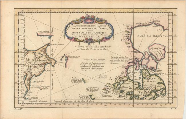
“Carte Reduite des Parties Septentrionales du Globe, Situees Entre l'Asie et l'Amerique pour Servir a l'Histoire Generale des Voyages”
Map Maker:
Jacques Nicolas Bellin
Very unusual chart that shows only the northeast c... (full text available to subscribers)
| Item Detail |
| |
| |
MapMaker: |
Jacques Nicolas Bellin
|
|
| |
| |
Subject: |
Arctic Ocean |
|
| |
Period/Size: |
1758 / 8.3" x 13.6" (21.1 x 34.6 cm)
|
|
| |
Color: |
Colored
|
|
| |
Condition: |
(A) Issued folding, now flattened, on watermarked paper with minor printer's ink residue and light toning along the edges of the sheet. (condition help) |
|
| |
Source: |
Prevost's Histoire Generale des Voyages |
|
| |
References: |
Kershaw #1115. |
|
| |
|
|
| Sales Information |
| |
| |
Price: |
|
|
| |
| |
Offered by: |
Old World Auctions |
|
| |
Catalog: |
Auction No. 169 - Antique Maps, Charts, Atlases & Globes (9467) |
|
| |
Lot/Item #: |
417 |
|
| |
| |
Date: |
09/2018
|
|
| |
| |
|
Antique Maps - Valuation and Pricing, Descriptions, Resources |
|
Home |
Information |
Search |
Register |
Contact Us |
Site Map
Americana Exchange, Inc. © 1999 - 2024 Americana Exchange, Inc.. All rights reserved.
OldMaps.com, the OldMaps.com logo and
AMPR are service marks or registered service marks of Americana Exchange, Inc..
|