Title:
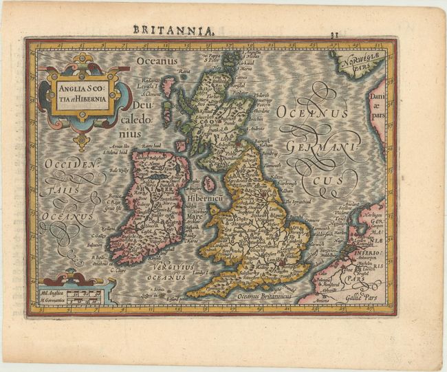
“Anglia Scotia et Hibernia”
Map Maker:
Mercator/Hondius
Handsome miniature map of the British Isles showin... (full text available to subscribers)
| Item Detail |
| |
| |
MapMaker: |
Mercator/Hondius
|
|
| |
| |
Subject: |
Britain |
|
| |
Period/Size: |
1610 / 5.3" x 7.1" (13.5 x 18.1 cm)
|
|
| |
Color: |
Colored
|
|
| |
Condition: |
(A) A dark impression with light toning along the edges of the sheet. (condition help) |
|
| |
Source: |
Atlas Minor |
|
| |
References: |
Shirley (BI to 1650) #311; Van der Krogt (Vol. III) #5000:351. |
|
| |
|
|
| Sales Information |
| |
| |
Price: |
|
|
| |
| |
Offered by: |
Old World Auctions |
|
| |
Catalog: |
Auction No. 169 - Antique Maps, Charts, Atlases & Globes (9467) |
|
| |
Lot/Item #: |
421 |
|
| |
| |
Date: |
09/2018
|
|
| |
| |
|
Antique Maps - Valuation and Pricing, Descriptions, Resources |
|
Home |
Information |
Search |
Register |
Contact Us |
Site Map
Americana Exchange, Inc. © 1999 - 2024 Americana Exchange, Inc.. All rights reserved.
OldMaps.com, the OldMaps.com logo and
AMPR are service marks or registered service marks of Americana Exchange, Inc..
|