Title:
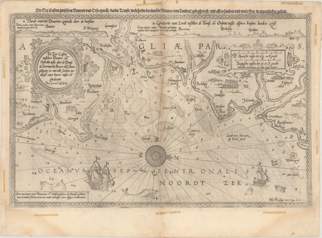
“De Zee Custen Tuschen Dovere en Orfordts Nesse, Daer de Teemse de Vermaerde Rivire va Lonen Gelegens is, met Alle Sanden Ondiepte, Naer Haren Wesen en Ghedaente”
Map Maker:
Lucas Jansz Waghenaer
A very early sea chart covering the southern coast... (full text available to subscribers)
| Item Detail |
| |
| |
MapMaker: |
Lucas Jansz Waghenaer
|
|
| |
| |
Subject: |
Southeastern England |
|
| |
Period/Size: |
1589 / 12.8" x 19.9" (32.6 x 50.6 cm)
|
|
| |
Color: |
Black & White
|
|
| |
Condition: |
(B+) Watermarked paper with light toning along the centerfold, some printer's ink residue, a few minor spots, and a short centerfold separation in top blank margin that has been closed on verso with paper tape. There are remnants of old tape confined to (condition help) |
|
| |
Source: |
Spieghel der Zeevaerdt |
|
| |
References: |
Shirley (BL Atlases) M.WAG-1a. |
|
| |
|
|
| Sales Information |
| |
| |
Price: |
|
|
| |
| |
Offered by: |
Old World Auctions |
|
| |
Catalog: |
Auction No. 169 - Antique Maps, Charts, Atlases & Globes (9467) |
|
| |
Lot/Item #: |
432 |
|
| |
| |
Date: |
09/2018
|
|
| |
| |
|
Antique Maps - Valuation and Pricing, Descriptions, Resources |
|
Home |
Information |
Search |
Register |
Contact Us |
Site Map
Americana Exchange, Inc. © 1999 - 2024 Americana Exchange, Inc.. All rights reserved.
OldMaps.com, the OldMaps.com logo and
AMPR are service marks or registered service marks of Americana Exchange, Inc..
|