Title:
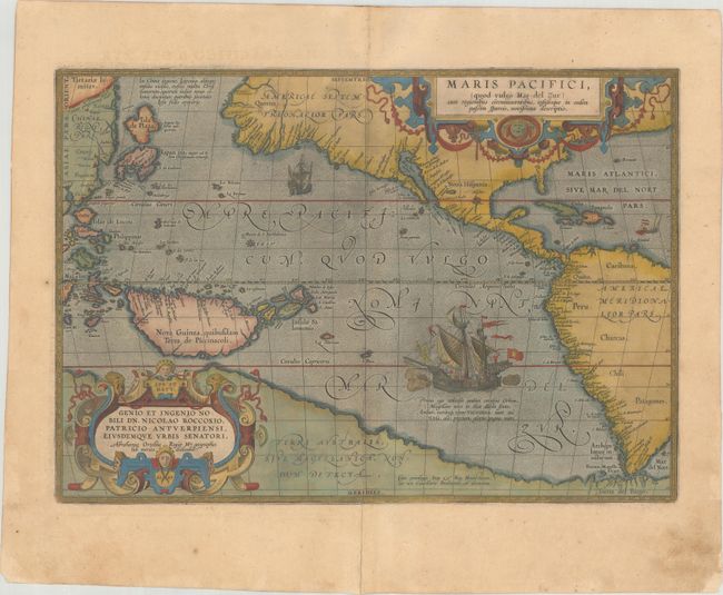
“Maris Pacifici, (quod Vulgo Mar del Zur) cum Regionibus Circumiacentibus, Insulisque in Eodem Passim Sparsis, Novissima Descriptio”
Map Maker:
Abraham Ortelius
Ortelius’ seminal map of the Pacific is the fir... (full text available to subscribers)
| Item Detail |
| |
| |
MapMaker: |
Abraham Ortelius
|
|
| |
| |
Subject: |
Pacific Ocean |
|
| |
Period/Size: |
1589 / 13.4" x 19.4" (34.1 x 49.3 cm)
|
|
| |
Color: |
Colored
|
|
| |
Condition: |
(B+) Superb full, contemporary color on watermarked paper with light soiling and an archivally repaired centerfold separation that enters a little over 3" into image at bottom. A small chip along the right edge of the sheet has been reattached with hinge (condition help) |
|
| |
Source: |
Theatrum Orbis Terrarum |
|
| |
References: |
Burden #74; Cohen, p. 31-33; Goss (NA) #14; Suarez (Pacific) p. 46, 65; Van den Broecke #12; Wheat (TMW) #24. |
|
| |
|
|
| Sales Information |
| |
| |
Price: |
|
|
| |
| |
Offered by: |
Old World Auctions |
|
| |
Catalog: |
Auction No. 169 - Antique Maps, Charts, Atlases & Globes (9467) |
|
| |
Lot/Item #: |
749 |
|
| |
| |
Date: |
09/2018
|
|
| |
| |
|
Antique Maps - Valuation and Pricing, Descriptions, Resources |
|
Home |
Information |
Search |
Register |
Contact Us |
Site Map
Americana Exchange, Inc. © 1999 - 2024 Americana Exchange, Inc.. All rights reserved.
OldMaps.com, the OldMaps.com logo and
AMPR are service marks or registered service marks of Americana Exchange, Inc..
|