Title:
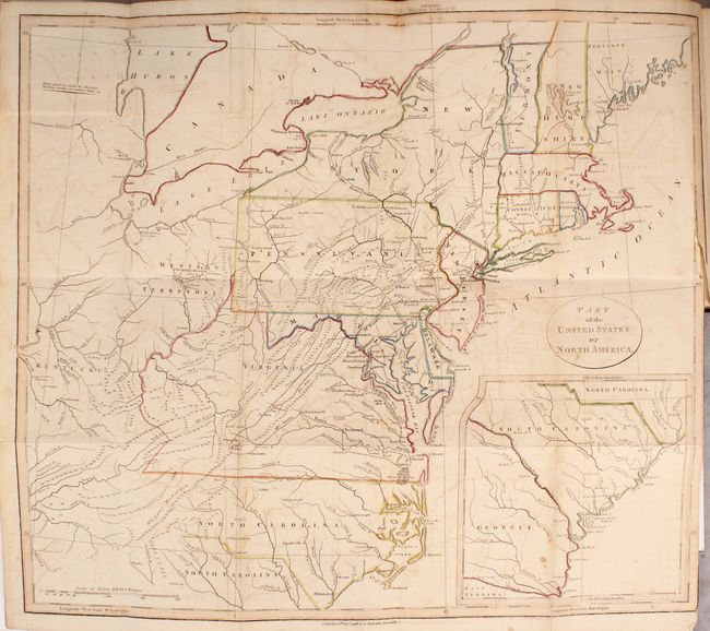
“Travels Through the States of North America, and the Provinces of Upper and Lower Canada, During the Years 1795, 1796, and 1797”
Map Maker:
Issac Weld
Weld, an Irish-born topographer, arrived to Philad... (full text available to subscribers)
| Item Detail |
| |
| |
MapMaker: |
Issac Weld
|
|
| |
| |
Subject: |
Books with maps, North America |
|
| |
Period/Size: |
1800 / 8.4" x 5.4" (21.4 x 13.8 cm)
|
|
| |
Color: |
Colored
|
|
| |
Condition: |
(B) The maps and plates are good to very good with scattered foxing and staining. The map of the eastern United States has light offsetting and a 3" binding tear at right. The text is very good with light toning and occasional pencil notations in the ma (condition help) |
|
| |
Source: |
|
|
| |
References: |
Howes #W-235; Sabin #102541; McCorkle #798.5. |
|
| |
|
|
| Sales Information |
| |
| |
Price: |
|
|
| |
| |
Offered by: |
Old World Auctions |
|
| |
Catalog: |
Auction No. 169 - Antique Maps, Charts, Atlases & Globes (9467) |
|
| |
Lot/Item #: |
791 |
|
| |
| |
Date: |
09/2018
|
|
| |
| |
|
Antique Maps - Valuation and Pricing, Descriptions, Resources |
|
Home |
Information |
Search |
Register |
Contact Us |
Site Map
Americana Exchange, Inc. © 1999 - 2024 Americana Exchange, Inc.. All rights reserved.
OldMaps.com, the OldMaps.com logo and
AMPR are service marks or registered service marks of Americana Exchange, Inc..
|