Title:
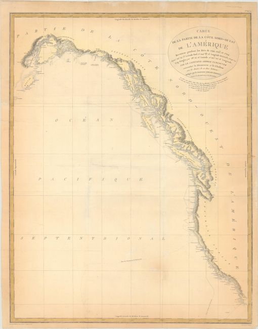
“Carte de la Partie de la Cote Nord-Ouest de l'Amerique Reconnue Pendant les Etes de 1792, 1793, et 1794...”
Map Maker:
George Vancouver
This remarkably detailed chart covers the entire s... (full text available to subscribers)
| Item Detail |
| |
| |
MapMaker: |
George Vancouver
|
|
| |
| |
Subject: |
Western North America |
|
| |
Period/Size: |
1799 / 29.1" x 22.9" (74.0 x 58.2 cm)
|
|
| |
Color: |
Colored
|
|
| |
Condition: |
(B) Issued folding, now flat, on watermarked paper with several tears that have been repaired on verso with archival materials. There is light to moderate toning along the map border. (condition help) |
|
| |
Source: |
Vancouver's Voyages (French Edition) |
|
| |
References: |
Falk #1799-3. |
|
| |
|
|
| Sales Information |
| |
| |
Price: |
|
|
| |
| |
Offered by: |
Old World Auctions |
|
| |
Catalog: |
Auction No. 169 - Antique Maps, Charts, Atlases & Globes (9467) |
|
| |
Lot/Item #: |
114 |
|
| |
| |
Date: |
09/2018
|
|
| |
| |
|
Antique Maps - Valuation and Pricing, Descriptions, Resources |
|
Home |
Information |
Search |
Register |
Contact Us |
Site Map
Americana Exchange, Inc. © 1999 - 2024 Americana Exchange, Inc.. All rights reserved.
OldMaps.com, the OldMaps.com logo and
AMPR are service marks or registered service marks of Americana Exchange, Inc..
|