Title:
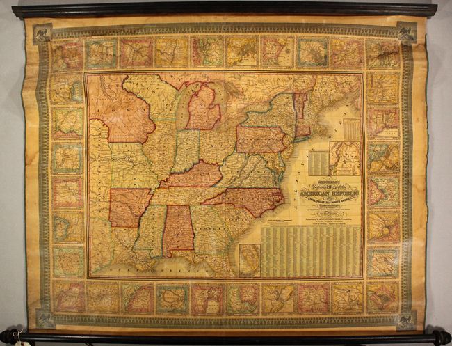
“Mitchell's National Map of the American Republic or United States of North America. Together with Maps of the Vicinities of Thirty-Two of the Principal Cities and Towns in the Union”
Map Maker:
Samuel Augustus Mitchell
This is a very nice wall map that was drawn by J.H... (full text available to subscribers)
| Item Detail |
| |
| |
MapMaker: |
Samuel Augustus Mitchell
|
|
| |
| |
Subject: |
Eastern United States |
|
| |
Period/Size: |
1845 / 33.5" x 42.2" (85.1 x 107.2 cm)
|
|
| |
Color: |
Colored
|
|
| |
Condition: |
(B+) The map is pleasantly toned due to the varnish along with a few minor abrasions and cracks. There are some dampstains at upper left and right that are mostly confined to the vignette border and blank margins. Minor soiling confined to the sheet cor (condition help) |
|
| |
Source: |
|
|
| |
References: |
|
|
| |
|
|
| Sales Information |
| |
| |
Price: |
|
|
| |
| |
Offered by: |
Old World Auctions |
|
| |
Catalog: |
Auction No. 169 - Antique Maps, Charts, Atlases & Globes (9467) |
|
| |
Lot/Item #: |
168 |
|
| |
| |
Date: |
09/2018
|
|
| |
| |
|
Antique Maps - Valuation and Pricing, Descriptions, Resources |
|
Home |
Information |
Search |
Register |
Contact Us |
Site Map
Americana Exchange, Inc. © 1999 - 2024 Americana Exchange, Inc.. All rights reserved.
OldMaps.com, the OldMaps.com logo and
AMPR are service marks or registered service marks of Americana Exchange, Inc..
|