Title:
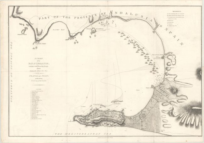
“A Chart of the Bay of Gibraltar, Including a Small Plan of That Fortress, with the Position of the Military & Naval Force of France and Spain, Present During the Late Siege of That Garrison”
Map Maker:
John Cheevers
This plan depicts the Great Siege of Gibraltar, th... (full text available to subscribers)
| Item Detail |
| |
| |
MapMaker: |
John Cheevers
|
|
| |
| |
Subject: |
Gibraltar, Spain |
|
| |
Period/Size: |
1785 / 17.8" x 26.2" (45.3 x 66.6 cm)
|
|
| |
Color: |
Black & White
|
|
| |
Condition: |
(B+) Issued folding with minor soiling and archival repairs to several short fold separations. There is a binding trim at right and an adjacent binding tear that just enters less than 1" into image that has also been archivally repaired. (condition help) |
|
| |
Source: |
|
|
| |
References: |
|
|
| |
|
|
| Sales Information |
| |
| |
Price: |
|
|
| |
| |
Offered by: |
Old World Auctions |
|
| |
Catalog: |
Auction No. 169 - Antique Maps, Charts, Atlases & Globes (9467) |
|
| |
Lot/Item #: |
520 |
|
| |
| |
Date: |
09/2018
|
|
| |
| |
|
Antique Maps - Valuation and Pricing, Descriptions, Resources |
|
Home |
Information |
Search |
Register |
Contact Us |
Site Map
Americana Exchange, Inc. © 1999 - 2024 Americana Exchange, Inc.. All rights reserved.
OldMaps.com, the OldMaps.com logo and
AMPR are service marks or registered service marks of Americana Exchange, Inc..
|