Title:
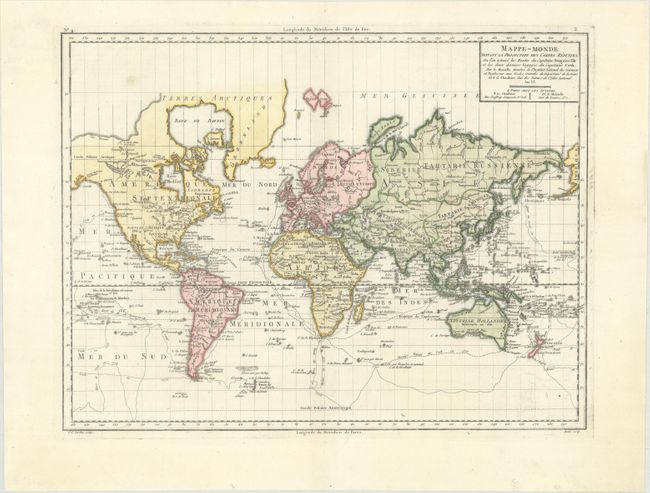
“Mappe-Monde Suivant la Projection des Cartes Reduites, ou l'on a Trace les Routes du Capitaine Bougainville et les Deux Derniers Voyages du Capitaine Cook...”
Map Maker:
Chanlaire & Mentelle
This handsome world map was drawn on Mercator's Pr... (full text available to subscribers)
| Item Detail |
| |
| |
MapMaker: |
Chanlaire & Mentelle
|
|
| |
| |
Subject: |
World |
|
| |
Period/Size: |
1798 / 12.8" x 16.7" (32.6 x 42.5 cm)
|
|
| |
Color: |
Colored
|
|
| |
Condition: |
(A) A crisp impression with faint offsetting at bottom right. (condition help) |
|
| |
Source: |
Atlas Universel de Geographie Physique et Politique |
|
| |
References: |
McGuirk #185. |
|
| |
|
|
| Sales Information |
| |
| |
Price: |
|
|
| |
| |
Offered by: |
Old World Auctions |
|
| |
Catalog: |
Auction No. 170 - Antique Maps, Charts, Atlases & Globes (9468) |
|
| |
Lot/Item #: |
040 |
|
| |
| |
Date: |
11/2018
|
|
| |
| |
|
Antique Maps - Valuation and Pricing, Descriptions, Resources |
|
Home |
Information |
Search |
Register |
Contact Us |
Site Map
Americana Exchange, Inc. © 1999 - 2024 Americana Exchange, Inc.. All rights reserved.
OldMaps.com, the OldMaps.com logo and
AMPR are service marks or registered service marks of Americana Exchange, Inc..
|