| Item Detail |
| |
| |
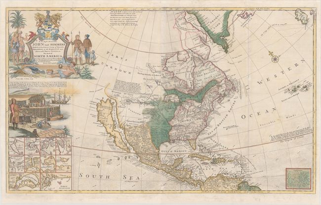
MapMaker: |
Herman Moll
|
|
| |
| |
Subject: |
Colonial North America |
|
| |
Period/Size: |
1755 / 23.1" x 38.3" (58.7 x 97.3 cm)
|
|
| |
Color: |
Colored
|
|
| |
Condition: |
(B+) Issued folding, now flattened with a small abrasion at bottom center and professional repairs to several short separations and tiny tears along the folds, as well as to a number of chips in the bottom blank margin, just passing the neatline along the (condition help) |
|
| |
Source: |
The World Describedģ |
|
| |
References: |
Goss (NA) #53; McLaughlin #192; cf. Schwartz & Ehrenberg, pl.79; Shirley (BL Atlases) T.MOLL-4c #9; Wheat (TMW) #105. |
|
| |
|
|
| Sales Information |
| |
| |
Price: |
|
|
| |
| |
Offered by: |
Old World Auctions |
|
| |
Catalog: |
Auction No. 170 - Antique Maps, Charts, Atlases & Globes (9468) |
|
| |
Lot/Item #: |
097 |
|
| |
| |
Date: |
11/2018
|
|
| |
| |
|