Title:
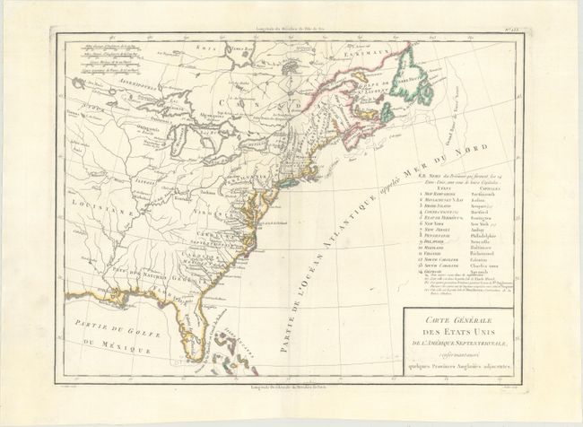
“Carte Generale des Etats Unis de l'Amerique Septentrionale, Renfermantaussi Quelques Provinces Angloises Adjacentes”
Map Maker:
Pierre Francois Tardieu
Nice early map of the United States with fourteen ... (full text available to subscribers)
| Item Detail |
| |
| |
MapMaker: |
Pierre Francois Tardieu
|
|
| |
| |
Subject: |
Eastern United States & Canada |
|
| |
Period/Size: |
1797 / 12.7" x 16.8" (32.3 x 42.7 cm)
|
|
| |
Color: |
Colored
|
|
| |
Condition: |
(A) A fine impression on a watermarked sheet with faint soiling and a pair of small wormholes around the centerfold that have been infilled with archival materials. (condition help) |
|
| |
Source: |
Atlas Universel de Geographie Physique et Politique |
|
| |
References: |
McCorkle #797.6. |
|
| |
|
|
| Sales Information |
| |
| |
Price: |
|
|
| |
| |
Offered by: |
Old World Auctions |
|
| |
Catalog: |
Auction No. 170 - Antique Maps, Charts, Atlases & Globes (9468) |
|
| |
Lot/Item #: |
132 |
|
| |
| |
Date: |
11/2018
|
|
| |
| |
|
Antique Maps - Valuation and Pricing, Descriptions, Resources |
|
Home |
Information |
Search |
Register |
Contact Us |
Site Map
Americana Exchange, Inc. © 1999 - 2024 Americana Exchange, Inc.. All rights reserved.
OldMaps.com, the OldMaps.com logo and
AMPR are service marks or registered service marks of Americana Exchange, Inc..
|