Title:
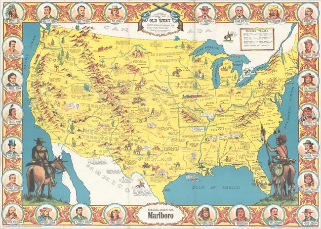
“Sheriff Danny Arnold's Pictorial Map of the Old West Showing Pioneer Trails and Battles, Indian Territories, Stagecoach Lines, Military Forts, Historical Data of the Frontier Period Around 1840”
Map Maker:
Infrequent Publ. - Anthropomorphic & Cartoon Maps
This pictorial map of the United States shows the ... (full text available to subscribers)
| Item Detail |
| |
| |
MapMaker: |
Infrequent Publ. - Anthropomorphic & Cartoon Maps
|
|
| |
| |
Subject: |
United States |
|
| |
Period/Size: |
1950 / 24.3" x 34.3" (61.8 x 87.2 cm)
|
|
| |
Color: |
Colored
|
|
| |
Condition: |
(B+) Issued folding with minor wear along some of the fold lines and several small fold separations that have been closed on verso with archival tape. (condition help) |
|
| |
Source: |
|
|
| |
References: |
|
|
| |
|
|
| Sales Information |
| |
| |
Price: |
|
|
| |
| |
Offered by: |
Old World Auctions |
|
| |
Catalog: |
Auction No. 170 - Antique Maps, Charts, Atlases & Globes (9468) |
|
| |
Lot/Item #: |
156 |
|
| |
| |
Date: |
11/2018
|
|
| |
| |
|
Antique Maps - Valuation and Pricing, Descriptions, Resources |
|
Home |
Information |
Search |
Register |
Contact Us |
Site Map
Americana Exchange, Inc. © 1999 - 2024 Americana Exchange, Inc.. All rights reserved.
OldMaps.com, the OldMaps.com logo and
AMPR are service marks or registered service marks of Americana Exchange, Inc..
|