| Item Detail |
| |
| |
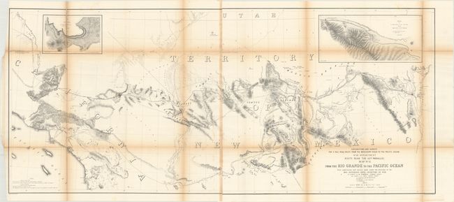
MapMaker: |
Amiel Weekes Whipple
|
|
| |
| |
Subject: |
Southwestern United States |
|
| |
Period/Size: |
1853-54 / 22.0" x 50.6" (55.9 x 128.6 cm)
|
|
| |
Color: |
Black & White
|
|
| |
Condition: |
(B) Folding, as issued, with toning along the folds and a few minor spots of foxing. There are some fold separations, as is typical for these maps, most of which have been reinforced on the verso with archival tape. (condition help) |
|
| |
Source: |
U.S. Pacific Railroad Surveys |
|
| |
References: |
Wheat (TMW) #875. |
|
| |
|
|
| Sales Information |
| |
| |
Price: |
|
|
| |
| |
Offered by: |
Old World Auctions |
|
| |
Catalog: |
Auction No. 170 - Antique Maps, Charts, Atlases & Globes (9468) |
|
| |
Lot/Item #: |
212 |
|
| |
| |
Date: |
11/2018
|
|
| |
| |
|