Title:
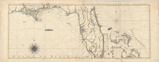
“Carte de la Floride Occidentale et Louisiane / La Peninsule et Golfe de la Floride ou Canal de Bahama avec les Isles de Bahama”
Map Maker:
George Louis Le Rouge
The scarce two-sheet map of Florida, the Bahamas, ... (full text available to subscribers)
| Item Detail |
| |
| |
MapMaker: |
George Louis Le Rouge
|
|
| |
| |
Subject: |
Florida |
|
| |
Period/Size: |
1777 / 18.2" x 47.2" (46.3 x 119.9 cm)
|
|
| |
Color: |
Colored
|
|
| |
Condition: |
(B+) A dark impression with light offsetting, a very small stain in southern Florida, and light damp stains that are mostly confined to the blank margins, just entering the image along the left-hand fold at top. (condition help) |
|
| |
Source: |
Pilote Americain Septentrional... |
|
| |
References: |
Shirley (BL Atlases) M.LER-1a #28-29. |
|
| |
|
|
| Sales Information |
| |
| |
Price: |
|
|
| |
| |
Offered by: |
Old World Auctions |
|
| |
Catalog: |
Auction No. 170 - Antique Maps, Charts, Atlases & Globes (9468) |
|
| |
Lot/Item #: |
248 |
|
| |
| |
Date: |
11/2018
|
|
| |
| |
|
Antique Maps - Valuation and Pricing, Descriptions, Resources |
|
Home |
Information |
Search |
Register |
Contact Us |
Site Map
Americana Exchange, Inc. © 1999 - 2024 Americana Exchange, Inc.. All rights reserved.
OldMaps.com, the OldMaps.com logo and
AMPR are service marks or registered service marks of Americana Exchange, Inc..
|