Title:
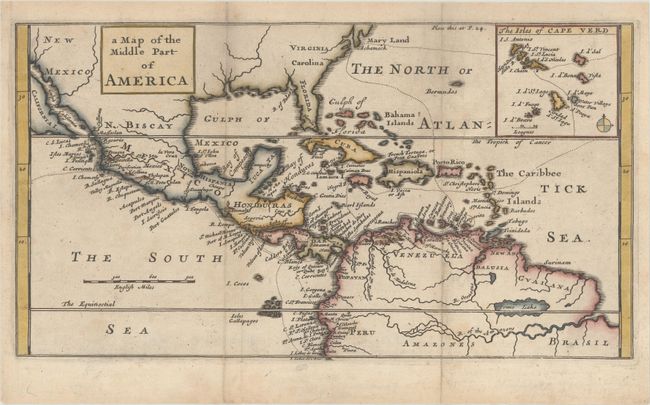
“A Map of the Middle Part of America”
Map Maker:
William Dampier
This chart shows part of the route of William Damp... (full text available to subscribers)
| Item Detail |
| |
| |
MapMaker: |
William Dampier
|
|
| |
| |
Subject: |
Gulf of Mexico & Caribbean |
|
| |
Period/Size: |
1703 / 6.1" x 11.2" (15.5 x 28.5 cm)
|
|
| |
Color: |
Colored
|
|
| |
Condition: |
(B+) Issued folding and now flattened with light surface soiling. The folds have been archivally reinforce on verso. (condition help) |
|
| |
Source: |
A New Voyage Round the World |
|
| |
References: |
Shirley (BL Atlases) G.DAM-1a #3. |
|
| |
|
|
| Sales Information |
| |
| |
Price: |
|
|
| |
| |
Offered by: |
Old World Auctions |
|
| |
Catalog: |
Auction No. 170 - Antique Maps, Charts, Atlases & Globes (9468) |
|
| |
Lot/Item #: |
363 |
|
| |
| |
Date: |
11/2018
|
|
| |
| |
|
Antique Maps - Valuation and Pricing, Descriptions, Resources |
|
Home |
Information |
Search |
Register |
Contact Us |
Site Map
Americana Exchange, Inc. © 1999 - 2024 Americana Exchange, Inc.. All rights reserved.
OldMaps.com, the OldMaps.com logo and
AMPR are service marks or registered service marks of Americana Exchange, Inc..
|