Title:
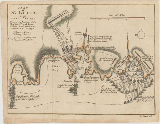
“Plan of St. Lucia, in the West Indies: Shewing the Positions of the English & French Forces with the Attacks Made at Its Reduction in Decr. 1778”
Map Maker:
Thomas Bowen
This is the first printed plan of the battle betwe... (full text available to subscribers)
| Item Detail |
| |
| |
MapMaker: |
Thomas Bowen
|
|
| |
| |
Subject: |
St. Lucia |
|
| |
Period/Size: |
1779 / 7.4" x 10.0" (18.8 x 25.4 cm)
|
|
| |
Color: |
Colored
|
|
| |
Condition: |
(B+) Issued folding with light toning and soiling. There are a couple of tiny tears along the edges of the sheet. (condition help) |
|
| |
Source: |
Gentleman's Magazine |
|
| |
References: |
Jolly #GENT-266; Nebenzahl (REV) #148; Sellers & Van Ee #2073. |
|
| |
|
|
| Sales Information |
| |
| |
Price: |
|
|
| |
| |
Offered by: |
Old World Auctions |
|
| |
Catalog: |
Auction No. 170 - Antique Maps, Charts, Atlases & Globes (9468) |
|
| |
Lot/Item #: |
397 |
|
| |
| |
Date: |
11/2018
|
|
| |
| |
|
Antique Maps - Valuation and Pricing, Descriptions, Resources |
|
Home |
Information |
Search |
Register |
Contact Us |
Site Map
Americana Exchange, Inc. © 1999 - 2024 Americana Exchange, Inc.. All rights reserved.
OldMaps.com, the OldMaps.com logo and
AMPR are service marks or registered service marks of Americana Exchange, Inc..
|