Title:
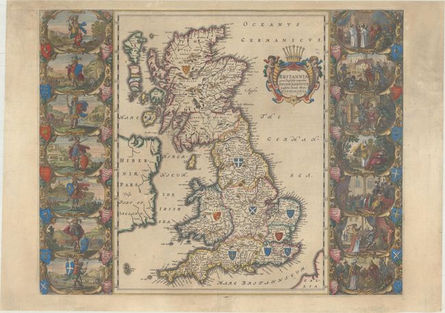
“Britannia Prout Divisa suit Temporibus Anglo-Saxonum, Praesertim Durante Illorum Heptarchia”
Map Maker:
Johannes Blaeu
Magnificent map of Anglo-Saxon Britain flanked by ... (full text available to subscribers)
| Item Detail |
| |
| |
MapMaker: |
Johannes Blaeu
|
|
| |
| |
Subject: |
Britain |
|
| |
Period/Size: |
1658 / 16.3" x 20.7" (41.4 x 52.6 cm)
|
|
| |
Color: |
Colored
|
|
| |
Condition: |
(B) Remargined at top and the upper portion of the right side margin. There are several small tears in the map and an edge tear at right that extends 2" into the decorative panel, all of which have been repaired on verso with archival material. Light su (condition help) |
|
| |
Source: |
Nuevo Atlas del Reyno de Inglaterra |
|
| |
References: |
Shirley (BI to 1650) #549; Van der Krogt (Vol. II) #5000H:2B. |
|
| |
|
|
| Sales Information |
| |
| |
Price: |
|
|
| |
| |
Offered by: |
Old World Auctions |
|
| |
Catalog: |
Auction No. 170 - Antique Maps, Charts, Atlases & Globes (9468) |
|
| |
Lot/Item #: |
448 |
|
| |
| |
Date: |
11/2018
|
|
| |
| |
|
Antique Maps - Valuation and Pricing, Descriptions, Resources |
|
Home |
Information |
Search |
Register |
Contact Us |
Site Map
Americana Exchange, Inc. © 1999 - 2024 Americana Exchange, Inc.. All rights reserved.
OldMaps.com, the OldMaps.com logo and
AMPR are service marks or registered service marks of Americana Exchange, Inc..
|