Rister or Sign In to see pricing information


Title:

Kaart van Londen Enz. en van het Naby Gelegen Land Ruim een Uur gaans, rondsom dezelve Stad…

Map Maker:

Isaac Tirion

Kaart van Londen Enz. en van het Naby Gelegen Land Ruim een Uur gaans, rondsom dezelve Stad…

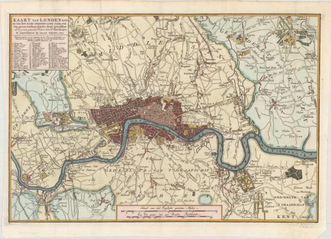
Attractive plan of London and the surrounding coun... (full text available to subscribers)
Item Detail
 
  MapMaker:  

Isaac Tirion


  Subject:  London, England  
  Period/Size:  1754 / 11.0" x 16.3"  (28.0 x 41.4 cm)  
  Color:  Colored  
  Condition:  (A) A sharp impression on watermarked paper, issued folding and now flattened with the bottom corner of the sheet trimmed, well away from the image. (condition help)  
  Source:   
  References:  Howgego #102.  
 
 
Sales Information
 
  Price: 

Please register your email to view records, or sign in with email address to see records


  Offered by:  Old World Auctions  
  Catalog:  Auction No. 170 - Antique Maps, Charts, Atlases & Globes (9468)  
  Lot/Item #:  461  
 
  Date:  11/2018  


Antique Maps - Valuation and Pricing, Descriptions, Resources


Home | Information | Search | Register | Contact Us | Site Map

Americana Exchange, Inc. © 1999 - 2024 Americana Exchange, Inc.. All rights reserved. OldMaps.com, the OldMaps.com logo and
AMPR are service marks or registered service marks of Americana Exchange, Inc..