Title:
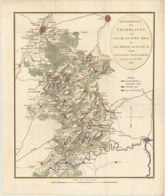
“Afteekening der Veldslagen van Lignij, Quatre Bras en la Belle Alliance, Tegen Napoleon Bonaparte, op 16, 17 en 18 Junij 1815”
Map Maker:
Johannes Fredericus Lange
This map depicts the Battle of Waterloo, which was... (full text available to subscribers)
| Item Detail |
| |
| |
MapMaker: |
Johannes Fredericus Lange
|
|
| |
| |
Subject: |
Central Belgium |
|
| |
Period/Size: |
1816 / 13.9" x 11.7" (35.3 x 29.8 cm)
|
|
| |
Color: |
Colored
|
|
| |
Condition: |
(A) Issued folding, now flattened, with very minor soiling and a couple of minute worm holes only visible when held to light. (condition help) |
|
| |
Source: |
|
|
| |
References: |
|
|
| |
|
|
| Sales Information |
| |
| |
Price: |
|
|
| |
| |
Offered by: |
Old World Auctions |
|
| |
Catalog: |
Auction No. 170 - Antique Maps, Charts, Atlases & Globes (9468) |
|
| |
Lot/Item #: |
489 |
|
| |
| |
Date: |
11/2018
|
|
| |
| |
|
Antique Maps - Valuation and Pricing, Descriptions, Resources |
|
Home |
Information |
Search |
Register |
Contact Us |
Site Map
Americana Exchange, Inc. © 1999 - 2024 Americana Exchange, Inc.. All rights reserved.
OldMaps.com, the OldMaps.com logo and
AMPR are service marks or registered service marks of Americana Exchange, Inc..
|