Title:
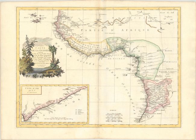
“Carte de la Guinee Contenant les Isles du Cap Verd, le Senegal, la Cote de Guinee Proprement Dite, les Royaumes de Loango, Congo, Angola et Benguela...”
Map Maker:
Santini/Remondini
This elegant map of western Africa is based on a m... (full text available to subscribers)
| Item Detail |
| |
| |
MapMaker: |
Santini/Remondini
|
|
| |
| |
Subject: |
Western Africa |
|
| |
Period/Size: |
1779 / 17.7" x 24.1" (45.0 x 61.3 cm)
|
|
| |
Color: |
Colored
|
|
| |
Condition: |
(B+) A crisp impression on a bright sheet with an "Imperial VO" watermark. There is light toning along the centerfold, some offsetting at right, and a small abrasion along the centerfold near the bottom or the image. (condition help) |
|
| |
Source: |
Atlas Universel... |
|
| |
References: |
|
|
| |
|
|
| Sales Information |
| |
| |
Price: |
|
|
| |
| |
Offered by: |
Old World Auctions |
|
| |
Catalog: |
Auction No. 170 - Antique Maps, Charts, Atlases & Globes (9468) |
|
| |
Lot/Item #: |
672 |
|
| |
| |
Date: |
11/2018
|
|
| |
| |
|
Antique Maps - Valuation and Pricing, Descriptions, Resources |
|
Home |
Information |
Search |
Register |
Contact Us |
Site Map
Americana Exchange, Inc. © 1999 - 2024 Americana Exchange, Inc.. All rights reserved.
OldMaps.com, the OldMaps.com logo and
AMPR are service marks or registered service marks of Americana Exchange, Inc..
|