Title:
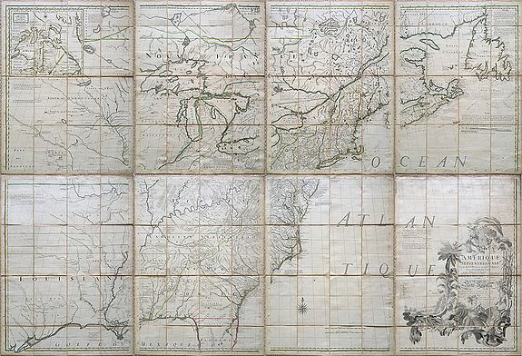
“Amerique Septentrionale avec les Routes, Distances en Miles, Limites et Etablissements Francois et Anglois par le Docteur Mitchel ... Corigee en 1776 par M. Hawkins.”
Map Maker:
Mitchell/Le Rouge
An engraved map in outline colour. On eight sheets... (full text available to subscribers)
| Item Detail |
| |
| |
MapMaker: |
Mitchell/Le Rouge
|
|
| |
| |
Subject: |
Canada & United States New data: 20191015180000 |
|
| |
Period/Size: |
1777 / 52.4" x 75.6" (133.1 x 192.1 cm)
|
|
| |
Color: |
Colored
|
|
| |
Condition: |
In original o./l. colouring. Some faint dust soiling and fingering, a few minor worm holes; very good condition. (condition help) |
|
| |
Source: |
|
|
| |
References: |
Ristow, A la Carte, pp 102-113 ( Rep in part ). Fite and Freeman, plate 47 ( Rep English edition ). |
|
| |
|
|
| Sales Information |
| |
| |
Price: |
|
|
| |
| |
Offered by: |
Paulus Swaen Old Maps & Prints |
|
| |
Catalog: |
October 15, 2019 Internet Auction (9473) |
|
| |
Lot/Item #: |
98920 |
|
| |
| |
Date: |
10/2019
|
|
| |
| |
|
Antique Maps - Valuation and Pricing, Descriptions, Resources |
|
Home |
Information |
Search |
Register |
Contact Us |
Site Map
Americana Exchange, Inc. © 1999 - 2024 Americana Exchange, Inc.. All rights reserved.
OldMaps.com, the OldMaps.com logo and
AMPR are service marks or registered service marks of Americana Exchange, Inc..
|