Title:
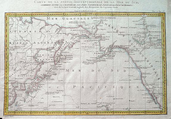
“Carte de la Partie Septentrionale de la Mer du Sud, Comprise entre la Californie, les Isles Sandwich le Japon et le Detr. de Behring”
Map Maker:
Louis Andre Dupuis
An unusual map of the northern Pacific, based upon... (full text available to subscribers)
| Item Detail |
| |
| |
MapMaker: |
Louis Andre Dupuis
|
|
| |
| |
Subject: |
North Pacific Ocean New data: Pacific Ocean |
|
| |
Period/Size: |
c. 1785 / 9.3" x 14.4" (23.7 x 36.6 cm)
|
|
| |
Color: |
Colored
|
|
| |
Condition: |
A copper plate engraving with hand colour. Slightly faded. Some old folds and a few small spots. (condition help) |
|
| |
Source: |
|
|
| |
References: |
|
|
| |
|
|
| Sales Information |
| |
| |
Price: |
|
|
| |
| |
Offered by: |
Paulus Swaen Old Maps & Prints |
|
| |
Catalog: |
October 15, 2019 Internet Auction (9473) |
|
| |
Lot/Item #: |
83160 |
|
| |
| |
Date: |
10/2019
|
|
| |
| |
|
Antique Maps - Valuation and Pricing, Descriptions, Resources |
|
Home |
Information |
Search |
Register |
Contact Us |
Site Map
Americana Exchange, Inc. © 1999 - 2024 Americana Exchange, Inc.. All rights reserved.
OldMaps.com, the OldMaps.com logo and
AMPR are service marks or registered service marks of Americana Exchange, Inc..
|