Title:
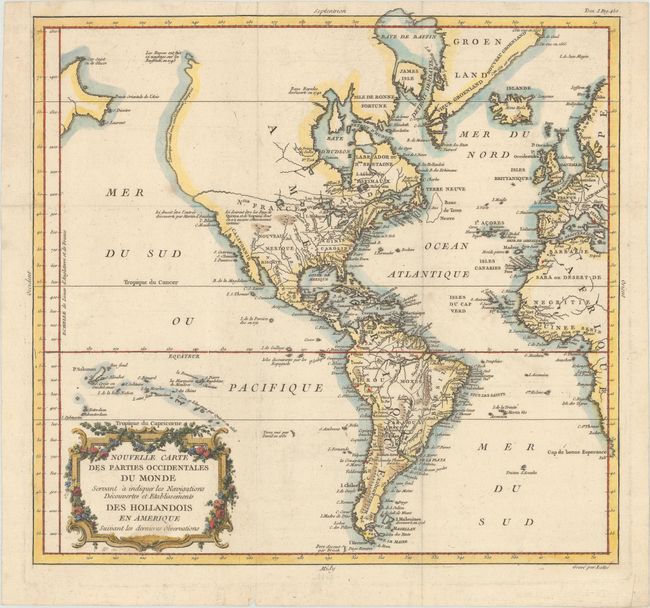
“Nouvelle Carte des Parties Occidentales du Monde Servant a Indiquer les Navigations Decouvertes et Etablissements des Hollandois en Amerique Suivant les Dernieres Observations”
Map Maker:
Etienne Andre Philippe De Pretot
A beautiful French edition of Tirion's 1754 map of... (full text available to subscribers)
| Item Detail |
| |
| |
MapMaker: |
Etienne Andre Philippe De Pretot
|
|
| |
| |
Subject: |
Western Hemisphere - America |
|
| |
Period/Size: |
1787 / 13.3" x 14.0" (33.8 x 35.6 cm)
|
|
| |
Color: |
Colored
|
|
| |
Condition: |
(A) A fine impression paper with a bunch of grapes watermark and a couple of faint spots. Issued folding with a binding trim at top left that has been replaced with old paper. (condition help) |
|
| |
Source: |
Genty's l'Influence de la Decouverte de l'Amerique |
|
| |
References: |
|
|
| |
|
|
| Sales Information |
| |
| |
Price: |
|
|
| |
| |
Offered by: |
Old World Auctions |
|
| |
Catalog: |
Auction No. 171 - Antique Maps, Charts, Atlases & Globes (9469) |
|
| |
Lot/Item #: |
87 |
|
| |
| |
Date: |
02/2019
|
|
| |
| |
|
Antique Maps - Valuation and Pricing, Descriptions, Resources |
|
Home |
Information |
Search |
Register |
Contact Us |
Site Map
Americana Exchange, Inc. © 1999 - 2024 Americana Exchange, Inc.. All rights reserved.
OldMaps.com, the OldMaps.com logo and
AMPR are service marks or registered service marks of Americana Exchange, Inc..
|