Title:
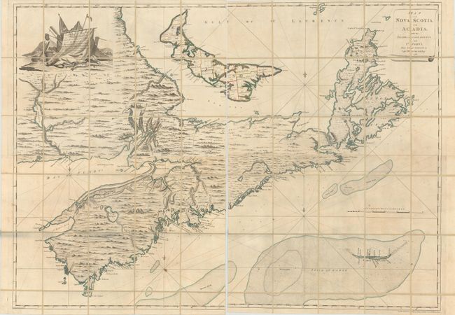
“Map of Nova Scotia, or Acadia; with the Islands of Cape Breton and St. John's, from Actual Surveys…”
Map Maker:
John Montresor
This impressive, linen-backed map covers the Marit... (full text available to subscribers)
| Item Detail |
| |
| |
MapMaker: |
John Montresor
|
|
| |
| |
Subject: |
Canadian Maritimes |
|
| |
Period/Size: |
1768 / 40.6" x 56.4" (103.2 x 143.3 cm)
|
|
| |
Color: |
Colored
|
|
| |
Condition: |
(B+) Original outline color on sheets that have been dissected and backed with linen. There is scattered foxing mainly at bottom, light soiling, and a hint of toning in the lower left quadrant. Please note that the first image is a composite image - the (condition help) |
|
| |
Source: |
|
|
| |
References: |
Kershaw #793; Sellers & Van Ee #312; Phillips (Maps) p. 624. |
|
| |
|
|
| Sales Information |
| |
| |
Price: |
|
|
| |
| |
Offered by: |
Old World Auctions |
|
| |
Catalog: |
Auction No. 171 - Antique Maps, Charts, Atlases & Globes (9469) |
|
| |
Lot/Item #: |
119 |
|
| |
| |
Date: |
02/2019
|
|
| |
| |
|
Antique Maps - Valuation and Pricing, Descriptions, Resources |
|
Home |
Information |
Search |
Register |
Contact Us |
Site Map
Americana Exchange, Inc. © 1999 - 2024 Americana Exchange, Inc.. All rights reserved.
OldMaps.com, the OldMaps.com logo and
AMPR are service marks or registered service marks of Americana Exchange, Inc..
|