Title:
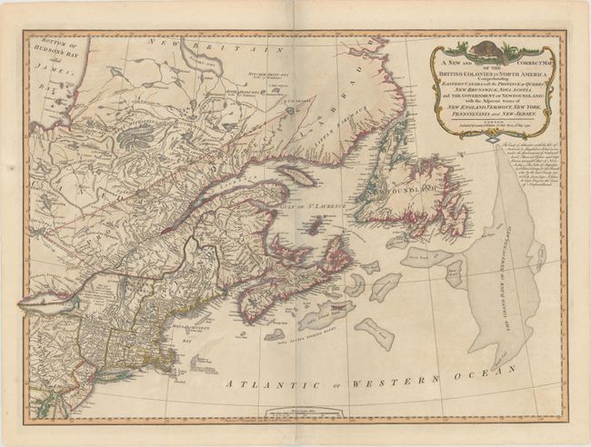
“A New and Correct Map of the British Colonies in North America Comprehending Eastern Canada with the Province of Quebec, New Brunswick, Nova Scotia, and the Government of Newfoundland: with the Adjacent States of New England...”
Map Maker:
Laurie & Whittle
This detailed map includes eastern Canada with Que... (full text available to subscribers)
| Item Detail |
| |
| |
MapMaker: |
Laurie & Whittle
|
|
| |
| |
Subject: |
Northeastern United States & Canada |
|
| |
Period/Size: |
1794 / 18.9" x 26.3" (48.0 x 66.8 cm)
|
|
| |
Color: |
Colored
|
|
| |
Condition: |
(B) A fine impression with original outline color and later coloring in the cartouche. There is light offsetting and the map has been separated along the centerfold and rejoined with archival materials. (condition help) |
|
| |
Source: |
A New and Elegant Imperial Sheet Atlas |
|
| |
References: |
Stevens & Tree (MCC-39) #65-c. |
|
| |
|
|
| Sales Information |
| |
| |
Price: |
|
|
| |
| |
Offered by: |
Old World Auctions |
|
| |
Catalog: |
Auction No. 171 - Antique Maps, Charts, Atlases & Globes (9469) |
|
| |
Lot/Item #: |
133 |
|
| |
| |
Date: |
02/2019
|
|
| |
| |
|
Antique Maps - Valuation and Pricing, Descriptions, Resources |
|
Home |
Information |
Search |
Register |
Contact Us |
Site Map
Americana Exchange, Inc. © 1999 - 2024 Americana Exchange, Inc.. All rights reserved.
OldMaps.com, the OldMaps.com logo and
AMPR are service marks or registered service marks of Americana Exchange, Inc..
|