Title:
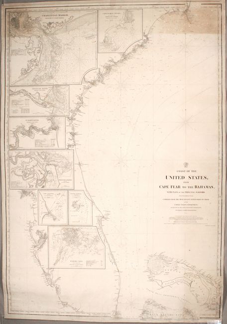
“Coast of the United States, from Cape Fear to the Bahamas, with Plans of the Principal Harbors on an Enlarged Scale...”
Map Maker:
U.S. Hydrographic Office
This large and richly detailed blue-backed chart b... (full text available to subscribers)
| Item Detail |
| |
| |
MapMaker: |
U.S. Hydrographic Office
|
|
| |
| |
Subject: |
Southeast United States, Bahamas |
|
| |
Period/Size: |
1865 / 51.5" x 35.0" (130.9 x 88.9 cm)
|
|
| |
Color: |
Black & White
|
|
| |
Condition: |
(B) There is toning in the top corners of the chart, light soiling that is more concentrated in the bottom right corner, and several short creases along the edges of the sheet. Two tears have been professionally repaired: a 5" tear at bottom and a 22" te (condition help) |
|
| |
Source: |
|
|
| |
References: |
|
|
| |
|
|
| Sales Information |
| |
| |
Price: |
|
|
| |
| |
Offered by: |
Old World Auctions |
|
| |
Catalog: |
Auction No. 171 - Antique Maps, Charts, Atlases & Globes (9469) |
|
| |
Lot/Item #: |
185 |
|
| |
| |
Date: |
02/2019
|
|
| |
| |
|
Antique Maps - Valuation and Pricing, Descriptions, Resources |
|
Home |
Information |
Search |
Register |
Contact Us |
Site Map
Americana Exchange, Inc. © 1999 - 2024 Americana Exchange, Inc.. All rights reserved.
OldMaps.com, the OldMaps.com logo and
AMPR are service marks or registered service marks of Americana Exchange, Inc..
|