Title:
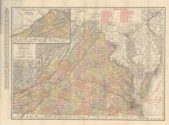
“The Rand McNally New Commercial Atlas Map of Virginia”
Map Maker:
Rand, McNally & Co.
This detailed map of the state is delineated by co... (full text available to subscribers)
| Item Detail |
| |
| |
MapMaker: |
Rand, McNally & Co.
|
|
| |
| |
Subject: |
Virginia |
|
| |
Period/Size: |
1915 / 18.9" x 25.8" (48.0 x 65.6 cm)
|
|
| |
Color: |
Colored
|
|
| |
Condition: |
(A) Issued folding with several tiny splits at fold intersections. A short edge tear that just touches the border at top left has been closed on verso with archival tape. Covers have minor wear. (condition help) |
|
| |
Source: |
|
|
| |
References: |
|
|
| |
|
|
| Sales Information |
| |
| |
Price: |
|
|
| |
| |
Offered by: |
Old World Auctions |
|
| |
Catalog: |
Auction No. 171 - Antique Maps, Charts, Atlases & Globes (9469) |
|
| |
Lot/Item #: |
299 |
|
| |
| |
Date: |
02/2019
|
|
| |
| |
|
Antique Maps - Valuation and Pricing, Descriptions, Resources |
|
Home |
Information |
Search |
Register |
Contact Us |
Site Map
Americana Exchange, Inc. © 1999 - 2024 Americana Exchange, Inc.. All rights reserved.
OldMaps.com, the OldMaps.com logo and
AMPR are service marks or registered service marks of Americana Exchange, Inc..
|