Title:
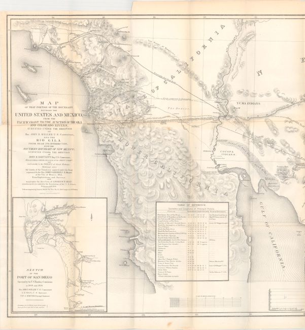
“Map of that Portion of the Boundary between the United States and Mexico, from the Pacific Coast to the Junction of the Gila and Colorado Rivers...and The Rio Gila from Near its Intersection with the Southern Boundary of New Mexico…”
Map Maker:
Andrew B. Gray
This map is part of the final documentation of the... (full text available to subscribers)
| Item Detail |
| |
| |
MapMaker: |
Andrew B. Gray
|
|
| |
| |
Subject: |
Southwestern United States & Mexico |
|
| |
Period/Size: |
1855 / 21.0" x 48.5" (53.4 x 123.2 cm)
|
|
| |
Color: |
Black & White
|
|
| |
Condition: |
(B+) Issued folding with faint toning along the fold lines and a few spots. There is a small hole in the profile at bottom and a 1" binding tear at left that has been closed on verso with archival tape. (condition help) |
|
| |
Source: |
Sen. Ex. Doc. 55, 33rd Congress, 2nd Session |
|
| |
References: |
Wheat (TMW) #821. |
|
| |
|
|
| Sales Information |
| |
| |
Price: |
|
|
| |
| |
Offered by: |
Old World Auctions |
|
| |
Catalog: |
Auction No. 171 - Antique Maps, Charts, Atlases & Globes (9469) |
|
| |
Lot/Item #: |
311 |
|
| |
| |
Date: |
02/2019
|
|
| |
| |
|
Antique Maps - Valuation and Pricing, Descriptions, Resources |
|
Home |
Information |
Search |
Register |
Contact Us |
Site Map
Americana Exchange, Inc. © 1999 - 2024 Americana Exchange, Inc.. All rights reserved.
OldMaps.com, the OldMaps.com logo and
AMPR are service marks or registered service marks of Americana Exchange, Inc..
|