Title:
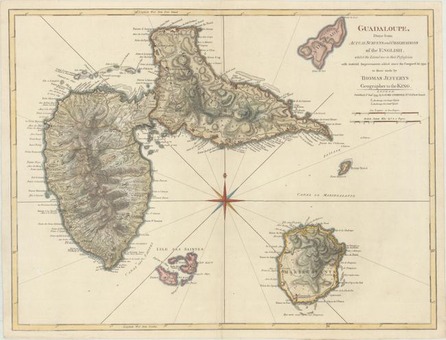
“Guadaloupe, Done from Actual Surveys and Observations of the English, Whilst the Island Was in Their Possession with Material Improvements Added Since the Conquest in 1794”
Map Maker:
Jefferys/Laurie & Whittle
A sharply engraved map with tremendous coastal det... (full text available to subscribers)
| Item Detail |
| |
| |
MapMaker: |
Jefferys/Laurie & Whittle
|
|
| |
| |
Subject: |
Guadeloupe |
|
| |
Period/Size: |
1795 / 18.1" x 24.0" (46.0 x 61.0 cm)
|
|
| |
Color: |
Colored
|
|
| |
Condition: |
(A) A nice impression on paper with the watermarks of a large fleur-de-lis coat of arms and the initials "RG." There are some minute worm holes only visible when held to light and a couple of minor creases. (condition help) |
|
| |
Source: |
The West-India Islands |
|
| |
References: |
cf. Shirley (BL Atlases) M.JEF-4a. |
|
| |
|
|
| Sales Information |
| |
| |
Price: |
|
|
| |
| |
Offered by: |
Old World Auctions |
|
| |
Catalog: |
Auction No. 171 - Antique Maps, Charts, Atlases & Globes (9469) |
|
| |
Lot/Item #: |
369 |
|
| |
| |
Date: |
02/2019
|
|
| |
| |
|
Antique Maps - Valuation and Pricing, Descriptions, Resources |
|
Home |
Information |
Search |
Register |
Contact Us |
Site Map
Americana Exchange, Inc. © 1999 - 2024 Americana Exchange, Inc.. All rights reserved.
OldMaps.com, the OldMaps.com logo and
AMPR are service marks or registered service marks of Americana Exchange, Inc..
|