Title:
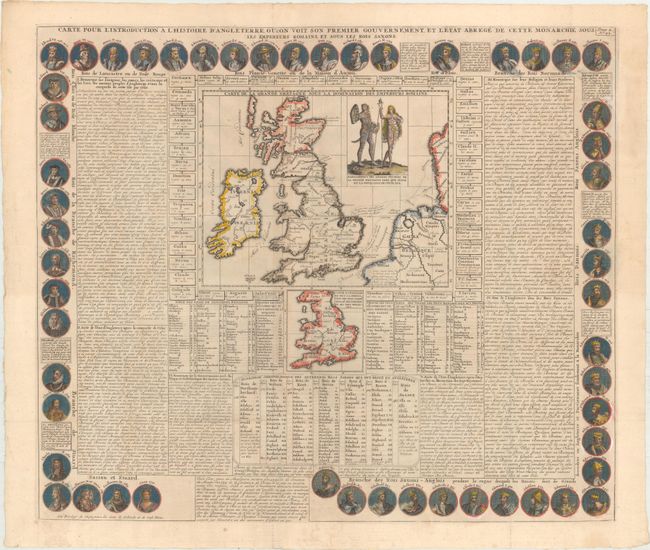
“Carte pour l'Introduction a l'Histoire d'Angleterre, ou l'on voit son Premier Gouvernement, et l'Etat Abrege de Cette Monarchie sous les Empereurs Romains, et sous les Rois Saxons”
Map Maker:
Henry Abraham Chatelain
This fascinating sheet centers on a map of Britain... (full text available to subscribers)
| Item Detail |
| |
| |
MapMaker: |
Henry Abraham Chatelain
|
|
| |
| |
Subject: |
Britain |
|
| |
Period/Size: |
1708 / 20.3" x 23.5" (51.6 x 59.7 cm)
|
|
| |
Color: |
Colored
|
|
| |
Condition: |
(B+) Issued folding with some faint dampstains mostly in the descriptive text. (condition help) |
|
| |
Source: |
Atlas Historique... |
|
| |
References: |
Shirley (BI to 1750) Chatelain 1. |
|
| |
|
|
| Sales Information |
| |
| |
Price: |
|
|
| |
| |
Offered by: |
Old World Auctions |
|
| |
Catalog: |
Auction No. 171 - Antique Maps, Charts, Atlases & Globes (9469) |
|
| |
Lot/Item #: |
434 |
|
| |
| |
Date: |
02/2019
|
|
| |
| |
|
Antique Maps - Valuation and Pricing, Descriptions, Resources |
|
Home |
Information |
Search |
Register |
Contact Us |
Site Map
Americana Exchange, Inc. © 1999 - 2024 Americana Exchange, Inc.. All rights reserved.
OldMaps.com, the OldMaps.com logo and
AMPR are service marks or registered service marks of Americana Exchange, Inc..
|