Title:
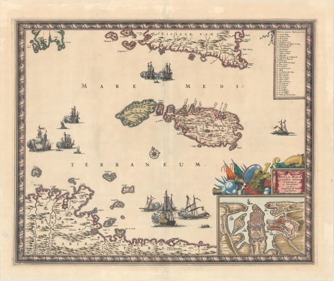
“Insula Malta Accuratissime Delineata, Urbibus, et Fortalitiis”
Map Maker:
Frederick de Wit
This superb map shows the strategic location of Ma... (full text available to subscribers)
| Item Detail |
| |
| |
MapMaker: |
Frederick de Wit
|
|
| |
| |
Subject: |
Malta |
|
| |
Period/Size: |
1680 / 17.3" x 21.3" (44.0 x 54.1 cm)
|
|
| |
Color: |
Colored
|
|
| |
Condition: |
(A) A strong impression with striking color with gilt highlights. There is very faint toning, a tiny hole in the top border of the inset, and professionally repaired centerfold separations at top and bottom that just enter the map border. There are some (condition help) |
|
| |
Source: |
|
|
| |
References: |
|
|
| |
|
|
| Sales Information |
| |
| |
Price: |
|
|
| |
| |
Offered by: |
Old World Auctions |
|
| |
Catalog: |
Auction No. 171 - Antique Maps, Charts, Atlases & Globes (9469) |
|
| |
Lot/Item #: |
603 |
|
| |
| |
Date: |
02/2019
|
|
| |
| |
|
Antique Maps - Valuation and Pricing, Descriptions, Resources |
|
Home |
Information |
Search |
Register |
Contact Us |
Site Map
Americana Exchange, Inc. © 1999 - 2024 Americana Exchange, Inc.. All rights reserved.
OldMaps.com, the OldMaps.com logo and
AMPR are service marks or registered service marks of Americana Exchange, Inc..
|