Title:
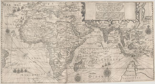
“Descriptio Hydrographica Accommodata ad Battavorum Navagatione in Javam Insulam Indiae Orientalis... / Eygentliche und Ausfuhrliche Mappa de Orientallischen Indien Darinen auch mit Puntten Angezeichnet di hin und wider um Reise der Hollander...”
Map Maker:
Theodore de Bry
This elaborate map, issued on two sheets and joine... (full text available to subscribers)
| Item Detail |
| |
| |
MapMaker: |
Theodore de Bry
|
|
| |
| |
Subject: |
Eastern Hemisphere |
|
| |
Period/Size: |
1599 / 14.1" x 26.1" (35.9 x 66.3 cm)
|
|
| |
Color: |
Black & White
|
|
| |
Condition: |
(B+) Issued folding with professional repairs to a number of small fold separations and three small tears in the center of the image, each approximately 1-1.5" wide. Trimmed to the neatline on all sides and to just inside the border at top right, as issu (condition help) |
|
| |
Source: |
Petits Voyages, Part III |
|
| |
References: |
Garratt (TMC-9) p. 10. |
|
| |
|
|
| Sales Information |
| |
| |
Price: |
|
|
| |
| |
Offered by: |
Old World Auctions |
|
| |
Catalog: |
Auction No. 172 - Antique Maps, Charts, Atlases & Globes (9470) |
|
| |
Lot/Item #: |
39 |
|
| |
| |
Date: |
04/2019
|
|
| |
| |
|
Antique Maps - Valuation and Pricing, Descriptions, Resources |
|
Home |
Information |
Search |
Register |
Contact Us |
Site Map
Americana Exchange, Inc. © 1999 - 2024 Americana Exchange, Inc.. All rights reserved.
OldMaps.com, the OldMaps.com logo and
AMPR are service marks or registered service marks of Americana Exchange, Inc..
|