Title:
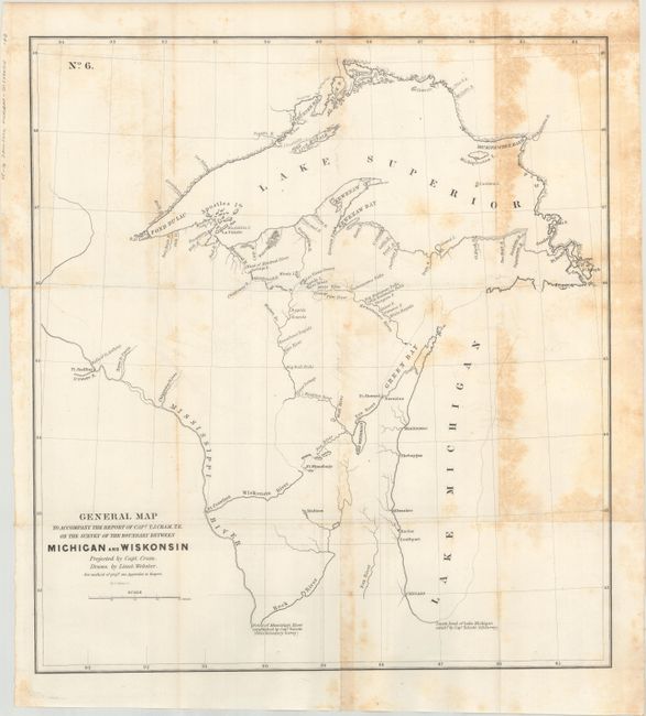
“General Map to Accompany the Report of Capt. T.J. Cram, T.E. on the Survey of the Boundary Between Michigan and Wiskonsin”
Map Maker:
Thomas Jefferson (Capt.) Cram
This important map documents Capt. Cram's second s... (full text available to subscribers)
| Item Detail |
| |
| |
MapMaker: |
Thomas Jefferson (Capt.) Cram
|
|
| |
| |
Subject: |
Wisconsin & Michigan |
|
| |
Period/Size: |
1842 / 18.3" x 16.9" (46.5 x 43.0 cm)
|
|
| |
Color: |
Black & White
|
|
| |
Condition: |
(B) Issued folding with scattered foxing that is concentrated at right. (condition help) |
|
| |
Source: |
|
|
| |
References: |
|
|
| |
|
|
| Sales Information |
| |
| |
Price: |
|
|
| |
| |
Offered by: |
Old World Auctions |
|
| |
Catalog: |
Auction No. 172 - Antique Maps, Charts, Atlases & Globes (9470) |
|
| |
Lot/Item #: |
163 |
|
| |
| |
Date: |
04/2019
|
|
| |
| |
|
Antique Maps - Valuation and Pricing, Descriptions, Resources |
|
Home |
Information |
Search |
Register |
Contact Us |
Site Map
Americana Exchange, Inc. © 1999 - 2024 Americana Exchange, Inc.. All rights reserved.
OldMaps.com, the OldMaps.com logo and
AMPR are service marks or registered service marks of Americana Exchange, Inc..
|