Title:
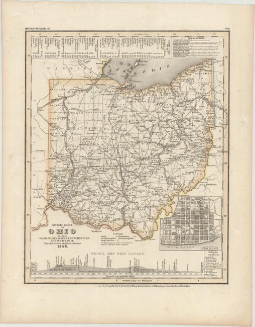
“Neueste Karte von Ohio mit Seinen Canaelen, Strassen & Entfernungen der Hauptpunkte. Nach den Bessten Quellen Verbessert”
Map Maker:
Joseph Meyer
Fine early map showing counties, roads, railroads,... (full text available to subscribers)
| Item Detail |
| |
| |
MapMaker: |
Joseph Meyer
|
|
| |
| |
Subject: |
Ohio |
|
| |
Period/Size: |
1845 / 14.6" x 11.8" (37.1 x 30.0 cm)
|
|
| |
Color: |
Colored
|
|
| |
Condition: |
(A) Contemporary color with minor foxing and soiling mostly confined to the blank margins. (condition help) |
|
| |
Source: |
Meyer's Hand-Atlas... |
|
| |
References: |
|
|
| |
|
|
| Sales Information |
| |
| |
Price: |
|
|
| |
| |
Offered by: |
Old World Auctions |
|
| |
Catalog: |
Auction No. 172 - Antique Maps, Charts, Atlases & Globes (9470) |
|
| |
Lot/Item #: |
252 |
|
| |
| |
Date: |
04/2019
|
|
| |
| |
|
Antique Maps - Valuation and Pricing, Descriptions, Resources |
|
Home |
Information |
Search |
Register |
Contact Us |
Site Map
Americana Exchange, Inc. © 1999 - 2024 Americana Exchange, Inc.. All rights reserved.
OldMaps.com, the OldMaps.com logo and
AMPR are service marks or registered service marks of Americana Exchange, Inc..
|